Stabilisation of deposits and maintenance work at Matjes River Rock Shelter
Matjes River rock shelter is a Provincial Heritage Site situated above the west bank at the mouth of the Matjes River, a small stream about 2 km east of Keurboomstrand in the Bitou Municipality in the Western Cape Province. Between 2000 and 12 000 years ago, long before European settlers came to South Africa, the shelter was used intermittently as a home by thousands of generations of San people who left their rubbish behind. By analysing the stone and bone tools, food remains such as shells and bones, and ornaments such as beads and pendants, as well as the bones of people buried there, archaeologists have been able to reconstruct information about the lifestyle of these Stone Age hunter-gatherers. The shelter is on private property and it was declared a national monument in 1953 under the Historical Monuments Act of 1934, and in 2000 became a Provincial Heritage Site when the National Heritage Resources Act (No. 25 of 1999) replaced the National Monuments Act (No. 29 of 1969).
Uncontrolled public access to the site is permitted either up aluminium steps from the beach and then along a narrow footpath on the hillside (approximately 30 minutes from the car park at Arch Rock), or along the beach and up a path from the river mouth when the tides and beach sand permit (approximately 20 minutes). It is estimated that between 1993 and 2009, nearly 500 people visited the site each year, mostly during the Christmas and Easter holidays. Archaeological excavations at the rock shelter were undertaken by staff of the National Museum in Bloemfontein over a period of more than 30 years from the 1920s to the 1950s. A T-shaped cutting excavated all the archaeological deposit along the back wall (a distance of 55 m) and through the centre of the midden (a distance of about 15 m), removing an estimated 2000 tons and isolating two large piles of in situ midden deposits that at one time were nearly 10 m high. In the early 1990s, the National Monuments Council raised funds locally and abroad to try to protect the deposits from on-going wind erosion and the activities of people who visited the site. In 1993 and 1994, Professor H J Deacon at the Department of Archaeology at the University of Stellenbosch made a detailed record of the stratigraphy and excavated a deep sounding to test the full depth of the deposits and obtain a new set of radiocarbon dates. The results were summarised in a MA thesis by Willemien Dockel in 1998.
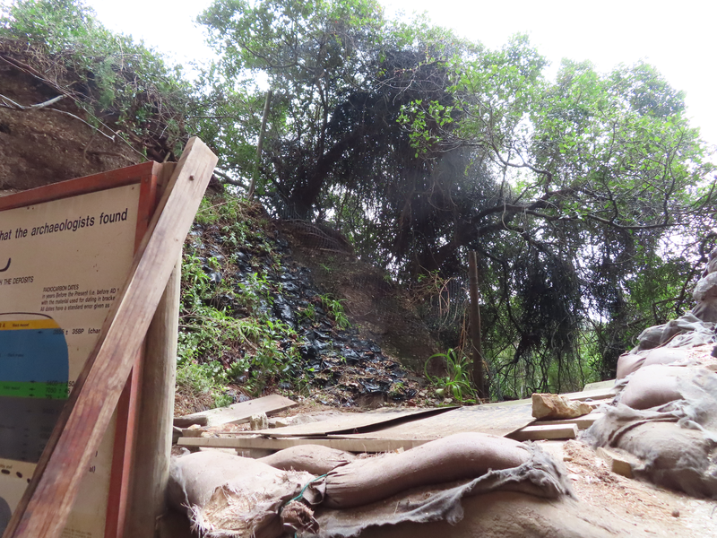
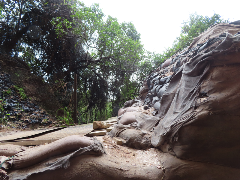
Consulting engineers Melis & Du Plessis, appointed by the National Monuments Council, recommended measures to protect and stabilise the slopes of the remaining deposits. Between 1994 and 1996, a boardwalk was constructed and sandbags, filled with soil sieved from the excavated deposits, were stacked against the exposed sides of the old excavations. The bags were covered with geotextile that was sewn around them to prevent damage from sunlight and rain. The work could unfortunately not be completed because there was not enough sand to fill the large number of bags required. Plans to use beach or river sand were postponed in 1997 because changes in the shoreline below the site had removed all the dry sand. A series of ‘peels’ of layers in the midden deposit was taken by National Monuments Council staff supervised by Dr Janette Deacon in 1996. They were fixed to an asbestos sheet mounted in a frame that was returned to the site by Mr Mike Brett in 1997. Although the sand bags and geotextile under cover of the roof of the shelter have not deteriorated, those in the middle of the midden have been damaged by sun, rain and baboons, and possibly by people as well. More seriously, the sections that have not been protected are being continuously eroded by the wind and there has been extensive collapse in some areas. The uppermost layers are in danger of being lost altogether if they are not protected soon. In addition, the wood on the boardwalk is showing signs of weathering and needs to be cleaned and re-sealed, and additional wood panels will help to prevent deposit from accumulating on the boardwalk.
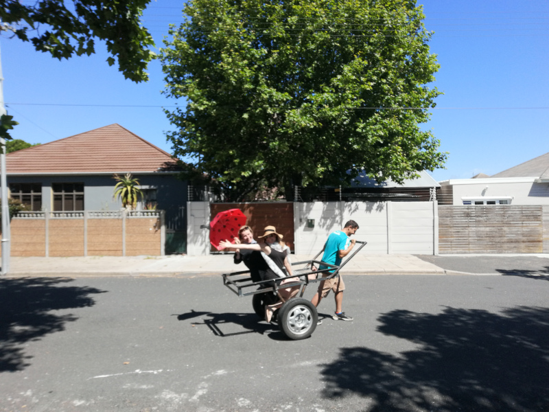
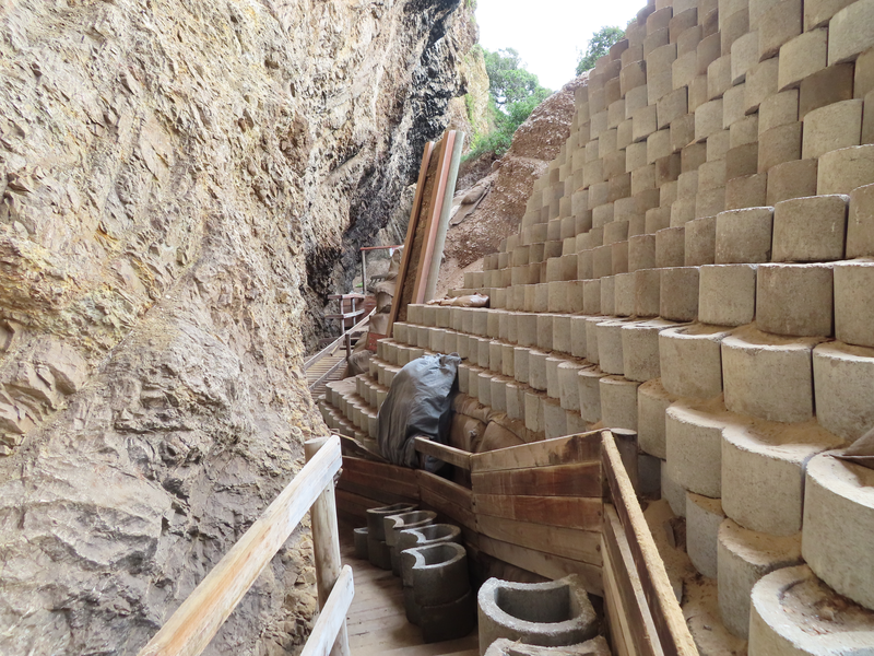
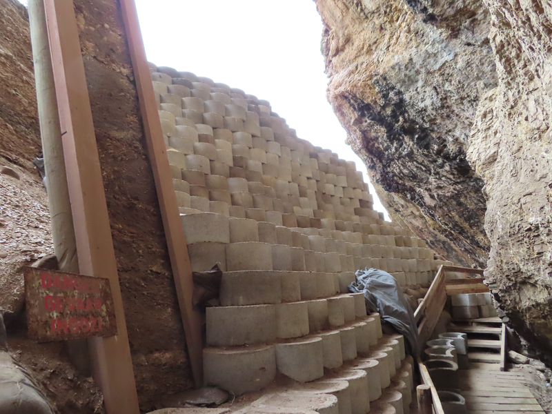
In 2021, staff from CTS Heritage and volunteers through OpenHeritage took up the initiative to move the stabilisation work forward. A permit was obtained from Heritage Western Cape and the remaining funds held by the South African Heritage Resources Agency were allocated towards the costs of the work. An area of about 60 square metres was measured out in need or urgent stabilisation. Various discussions took place and it was decided to use concrete retaining wall blocks instead of beach sand and sandbags as funds were not available to conduct an EIA process towards a mining permit for the large volume of sand required to stabilise the deposits. A steel trolley/cart was constructed based on images of similar handdrawn carts used to haul water and goods in many African cities and second-hand rims, tyres and wheel hubs were welded to build the cart ahead of the work in Keurboomstrand. A trial run on deep sand took place with two volunteers in tow so we we knew that the cart could at least carry 100-200kg without much difficulty.
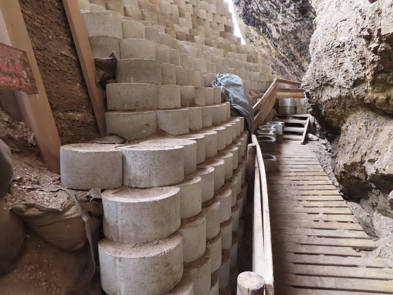
1080 Terraforce L18 blocks were procured from Mobicast in Mossel Bay and were delivered to the Enrico's Restaurant parking lot in Keurboomstrand on 01 February 2022. The blocks were then moved, 20 at a time, to Mr Sunley Uys's campsite above a set of steps leading down to the beach in a temporary holding area. The main work began on Monday 28 March and a local crew was hired to assist in hauling the blocks from the holding area, down the steps to the beach, onto the cart and then onto the site, 500m away along the beach. The crew varied from 8 to 25 depending on the amount of work needed on the day and towing straps were attached to the front of the cart to create enough force to move 16-18 blocks at a time. Each block weighs between 18-20kg and the beach conditions varied between low and high tide. This significantly impacted on the towing crew's lap times in moving the blocks along the beach as the softer sand further away from the sea slowed movement down. However, we managed to move about 500 blocks by midday on Wednesday when the spring tide hit us and indundated our temporary holding area on the beach. We had to scramble the crew to move about 30 blocks back up the beach and had to abandon further hauling for the day. Efforts were moved to the main holding area on the banks of the Matjes River to complete the hardest leg which was to move each block up the ~50m forest path to the site. Part of our volunteer crew worked up at the site the entire week to install the blocks up the exposed sections of the deposit. The spring tide continued into Thursday and Friday but we were still able to move another 350 blocks to the base of the forest trail during low tide. These blocks were carried up to two holding areas at the site leaving about 225 blocks at Mr Uys's place as we had enough blocks to complete the work up at the site. The 225 blocks have subsequently been taken over by Xantara Civils in Plettenberg Bay who removed the blocks from Mr Uys's holding area.
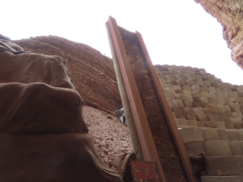
The main exposed section of deposit where most of the unstable deposits were collapsing has been stabilised using just under 400 blocks. About 450 blocks remain in the holding areas at the entrance to the site and these will be used in the T-junction area later this year. The original measurements included the area behind the large frame holding the peels taken of the archaeological sections and this area cannot hold blocks without removing the entire frame and causing more deposit to collapse. We are therefore going to stablise this area using sandbags. The remaining work, besides the completion of the installation of the blocks and sandbags, involves the boardwalk which needs sanding, replacement of some planks and treatment. A site cleanup will also take place to remove old equipment stored up at the site and to replace the worn/rusted signage. A large bush has grown into the middle of the access path and this will be cut out before stabilising an eroded side path that has developed over the years to walk around the bush. Geotextile cloth (biddum) covering the new sandbags will be sewn and treated with cement slurry to round off the maintenance work.
We would like to thank our crew (Mangaliso, Luvuyo, Peter, Joe, Junior, Richard, Tabson, Tony) from Kwanokuthula who will be working with us again later in the year as well as the following volunteers:
Crew Leaders -
Jenna Lavin and Nicholas Wiltshire from CTS Heritage,
William Archer from the National Museum in Bloemfontein,
Alexandra Jongens (an eCRAG member from Cape Town)
Steven Jacobson & Julian Jacobson
UCT student volunteers included Patricia Groenewald, Oriphulusa Nyadzhiwa and Tibora Khumalo
Dr Janette Deacon was on site with her family (Melissa, Rob, Max and Charlotte)
SAHRA officials, Phillip Hine and Ragna Redelstorff visited us on site and brought much needed sandbags. Phillip Hine is also the permit holder and is coordinating the reimbursement of costs spent on the work from the funds at SAHRA
Mr Sunley Uys for providing the first holding area for the blocks
Graham Reed for assistance with finding members of our crew
Bertha Ollermans and Jock Worthing for arranging accommodation in Keurboomstrand free of charge for our volunteer crew
Jennifer Booth and Jenna Newton from Toring Management on behalf of the owners of the property on which Matjes River Rock Shelter is situated
Selected images are being posted to the ArchSoc Instagram page as well as some videos taken by Alex Jongens.
 |
 |
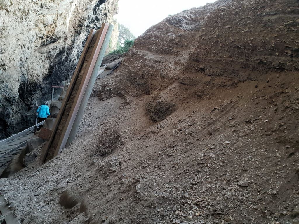 |
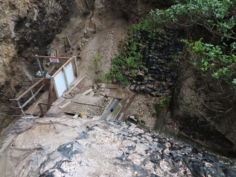
| Trailer design inspiration, Alamy Stock Photo 2021. | Our cart being tested in Plumstead in 2021.... | Matjes River Rock Shelter deposits in 2020 needing stabilisation. |
 |
 |
 |
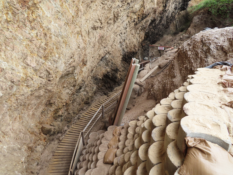
| View of the peel frame and blocks installed in March 2022. | View of the blocks installed in 2022 looking back down the boardwalk. | View of the blocks installed looking along boardwalk on the way to the t-junction. |
 |
 |
 |
| View of the blocks installed, main section. | View of the left hand side of the t-junction needing blocks. | View of the right hand side of the t-junction needing blocks. |
 |
 |
|
| View of the t-junction, top down. | View of the blocks installed, top down. |